Mystery Valley Karst Preserve and Nature Sanctuary
Co-owned by the MKC and the Michigan Nature Association
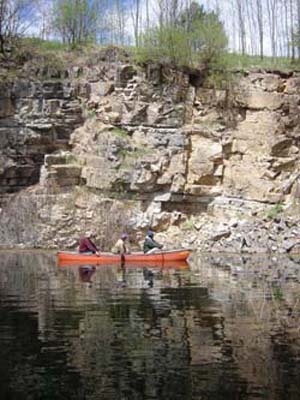
MKC members canoe in the lake that covers part of the floor of Mystery Valley.
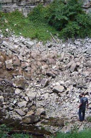
Collapse rubble along the valley floor.
Mystery Valley is a unit of the Thunday Bay Karst Preserve, along with Stevens Twins Sinks and Bruski Sink.
The 76-acre Mystery Valley Karst Preserve and Nature Sanctuary is located in Presque Isle County just a few miles north of the Thunder Bay Karst Preserve. It contains one of the largest karst “collapse valleys” in the Great Lakes region, several dramatic earth cracks and a lake that rises and falls, and sometimes disappears.
Visitors to the preserve can follow two self-guided trails: Earthcrack Trail and Valley Trail. Not surprisingly, Earthcrack Trail passes a series of cracks, including two that converge into one that’s several hundred feet long and nearly 15 feet deep. Following the Valley Trail, visitors can see fossils of marine inverterbrates such as brachiopods, bryzoa and crinoids that lived some 350 million to 400 million years ago.
Unlike a valley carved by a river, Mystery Valley was formed by the collapse of the surface into a labyrinth of subterranean chambers created by the water erosion of rock below. Mystery Valley is 1.5 miles long, 500 yards wide at its widest point and about 150 deep, making it one of the largest known collapse valleys in the Great Lakes region.
A thick layer of Devonian limestone and shale, known as the Traverse Group, underlies Alpena and Presque Isle counties. Below that, about 800 feet deep, lies the Detroit River Group, which contains large amount of the evaporites anhydrite and gypsum. These minerals dissolve much more readily than limestone, and as the Detroit River Group rocks erode and create caverns, Traverse Group rocks above collapse into the caverns.
Water rising from beneath the surface often creates a lake that covers the west and lower end of the valley. Most of the water reaches the surface through a sinkhole in the bedrock at the west end of the valley, which is hidden from view. Rain and snowmelt add water to the lake. As water flows through the underground drainage system toward Lake Huron, the lake drains back through the sinkhole (now acting as a swallow hole) and disappears. Sometimes the water drains so quickly a whirlpool forms over the sinkhole.
Along with the preservation and study of karst features, a main goal of the management plan adopted by the MKC and the MNA is removal of non-native and invasive plant species.